Ancient Civilization
Spaceships, Star Maps or Sacred Walks? The Many Theories Behind Peru's Nazca Lines
By Darrell Wallen
Would you prefer to listen?
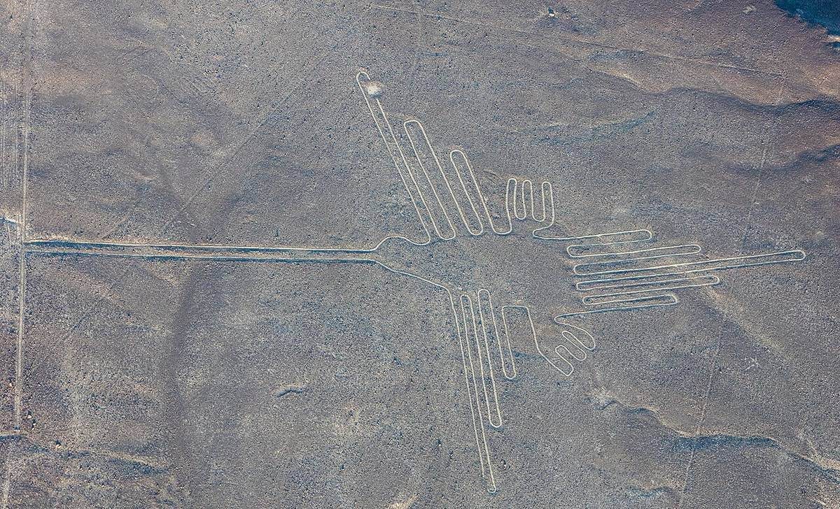
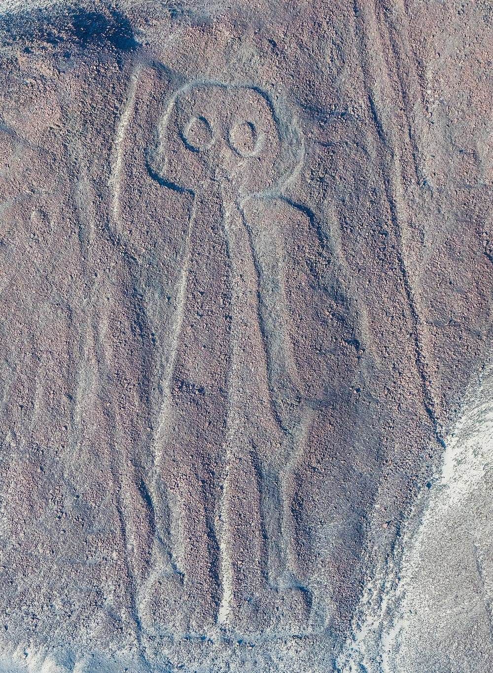
About 2,000 years ago, people in a Peruvian desert drew a monkey, a spider and a hummingbird so large that they are best seen from the sky. They left no writing to say why. For nearly a century, people have offered answers: a calendar of the stars, landing strips for visitors from space, balloon flights, maps of hidden water, and sacred walks. Now computers are finding hundreds of figures nobody knew were there, and the mystery keeps growing.
§ 1What is on record
The Nazca Lines lie on a high, dry plain in southern Peru, about 250 miles south of Lima. Laid end to end, they would run more than 800 miles. There are straight lines, spirals, giant trapezoids, animals and plants. The longest straight line runs nine miles. One pelican is 1,000 feet long.
The makers moved the dark stones on the surface to show the pale ground below. Almost no rain falls here, so the marks have lasted.
Most researchers credit the Nazca people, who lived in the river valleys nearby. The figures look much like the art on Nazca pottery. Broken pots lie on and near the lines. A wooden stake at the end of one long line was carbon-dated to about A.D. 525. Researchers at Yamagata University in Japan say use of the plain began by at least the first century B.C. It went on into the 1400s.
What the record lacks is an explanation. "The question of why the geoglyphs exist is difficult to answer, given that we lack any type of preserved oral or written testimony," wrote Karsten Lambers of the University of Augsburg. A geoglyph is a picture made on the ground.
The first answer came from a Peruvian. Archaeologist Toribio Mejía Xesspe spotted the lines while hiking in the hills in the 1920s. He later proposed that they were religious, ceremonial roads. Many more ideas would follow.
§ 2The greatest book of the stars
In June 1941, an American historian named Paul Kosok came to Nazca to study ancient water systems. At first he took the lines for ditches. Then, on the day of the southern winter solstice, he watched the sun go down almost exactly at the end of a long line.
Kosok decided the lines were tied to the sky. The Maria Reiche association, which preserves her work, records that he called the plateau "the greatest astronomical book of the world."
Maria Reiche, a German-born mathematician, took up the question. She began work on the desert in 1946 and stayed for more than 40 years. She moved into a simple hut with no water or power. With a tape, a sextant and a compass, she measured almost 1,000 lines. She came to believe she was looking at a huge calendar.
The idea has been tested many times since. In the late 1960s, astronomer Gerald Hawkins used a computer to check the lines against the sky. About one line in five matched the rising or setting of the sun or moon. The animal figures showed no steady match to the stars. Archaeologist William Isbell later noted that this was still twice what chance would give.
A 2021 study led by Christiane Richter found that only a small number of the figures lined up with a star or a solstice. Her team wrote that the figures "as a whole, certainly cannot be interpreted as a calendar system." Even so, Richter told Live Science that about 8 percent seem to have some link to the moon. She called it "highly probable that celestial bodies played a role in the creation of the drawings."
§ 3Visitors from the sky
No idea about Nazca is better known than the one Erich von Däniken made famous. The Swiss author published Chariots of the Gods in 1968. Here is what he wrote: "Seen from the air, the clear-cut impression that the 37-mile-long plain of Nazca made on me was that of an airfield! What is so far-fetched about the idea?"
He went further in later years. He wrote that "unknown intelligences landed on the uninhabited plain" and "built an improvized airfield for their spacecraft." He said the lines could have been "built according to instructions from an aircraft." He saw the big drawings as "signals" and the longest, widest lines as "landing strips."
Von Däniken knew that Nazca pottery lay beside the lines. He answered: "But it is surely oversimplifying things to attribute the geometrically arranged lines to the Nazca culture for that reason alone." His larger complaint was with the experts. They would not admit, he wrote, that these early people could have had "a perfect surveying technique." The idea of aircraft in ancient times, he wrote, "is sheer humbug to them."
The thought was older than his book. James Moseley floated a similar idea in Fate magazine in 1955. Kosok himself wrote in 1947 that the lines, first seen from the air, "were nicknamed prehistoric landing fields." It was said in fun.
Von Däniken died in January 2026 at age 90. No dig has found evidence of visitors from space so far. His question still gets asked, and his book is a big reason the world knows the name Nazca.
§ 4Did someone fly?
The hardest question is also the simplest. How did people draw something this big and this accurate if they could never see it from above?
Jim Woodman flew over the plain in an airplane and came down sure of his answer. "I know damned well someone flew at Nazca," he wrote in his book, Nazca: Journey to the Sun. "You simply can't see anything from ground level."
Woodman claimed the graves around Nazca held clues. They held finely woven cloth and braided rope. He said one clay pot seemed to show a hot-air balloon with tie ropes.
So he built one. With the International Explorers Society and British balloonist Julian Nott, he made a balloon using materials the Nazca people had. The basket was woven from totora reed from Lake Titicaca by the man who built Thor Heyerdahl's Ra raft. Smoke from a wood fire sealed the cloth and filled it with hot air.
On November 28, 1975, the two men took off. Condor I climbed past 300 feet. It came down fast, and they threw out sacks of weight. They jumped clear about ten feet off the ground. Freed of their weight, the balloon shot back into the sky.
"When we first made the flight it was amazing that we could actually leave the ground with thousand year old technology," Nott wrote. "With just a loom and fire you can fly!" He was also careful about what it proved. He wrote that he saw no evidence that the Nazca people did fly. But, he added, "it is beyond any doubt that they could have."
Others point out that the lines can be seen from the nearby foothills, and that some figures can be made out from the ground.
§ 5Stakes, string and a nine-hour condor
In 1982, a writing teacher and former stage magician named Joe Nickell tried a very different test. He wanted to copy a Nazca figure using only tools the Nazca people could have had.
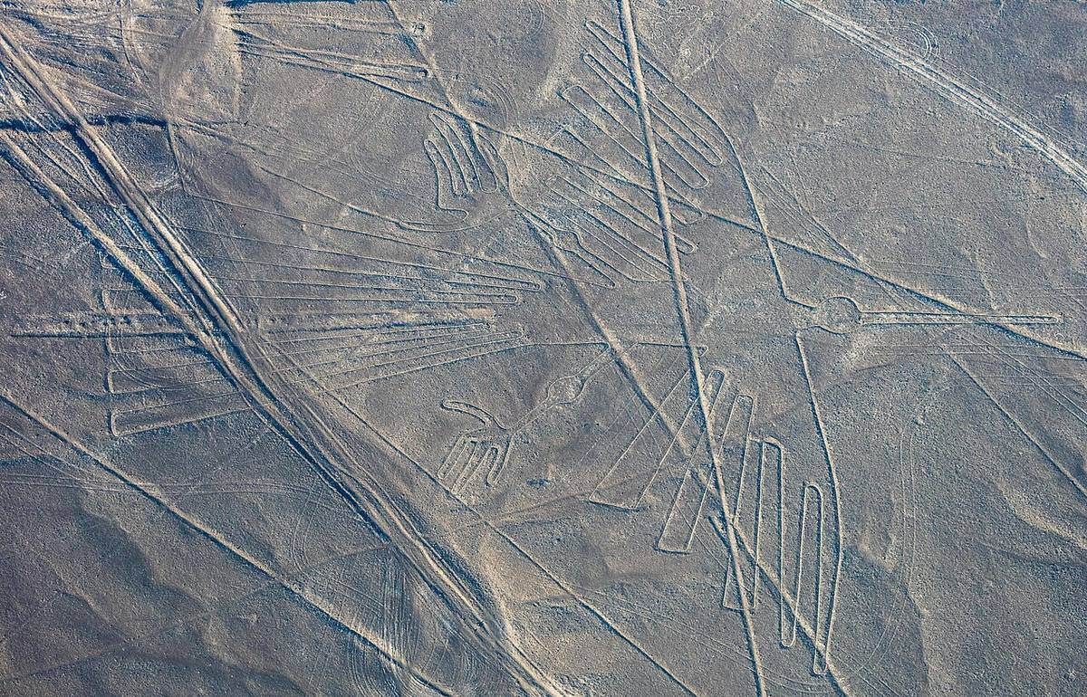
On August 7, Nickell and five relatives met on a landfill in West Liberty, Kentucky. One helper was his 11-year-old nephew. Their target was a 440-foot condor. They used a small drawing, a center line, knotted ropes and a "T" made from two strips of wood.
The ropes were marked in a unit of about 12.68 inches. Maria Reiche had worked out that unit from the drawings. Point by point, they measured from the center line on the small drawing, then did the same at full size. In about nine hours they staked 165 points and joined them with string. After a week of rain, they marked the lines with white lime.
Then a pilot took them up to just under 1,000 feet. The bird was there. "In fact the results were so accurate that we are convinced we could have easily produced a more symmetrical figure by this method," Nickell wrote.
Reiche had described much of this method herself. She found small plots near the big figures, about six feet square, where she believed the first sketches were made. A rope between two stakes makes a straight line. A rope tied to a stake makes a curve. Explorer Tony Morrison showed that a row of poles can keep a line straight for miles.
Isbell had another idea, that weavers enlarged the figures on a grid, the way a loom lays out a pattern.
Nickell's condor shows the job could be done this way. It cannot show that it was. Reiche herself suspected there was more to it. She once wrote: "Ancient Peruvians must have had instruments and equipment which we ignore and which together with ancient knowledge were buried and hidden from the eyes of the conquerors as the one treasure which was not to be surrendered."
§ 6Follow the water
In a place this dry, water may be the key. Near the lines are the puquios, stone-lined spiral shafts that drop down to underground canals. Rosa Lasaponara, an Italian researcher who studied them by satellite, believes the spirals pulled wind into the canals and helped push the water along. She said the job took "particularly specialized technology."
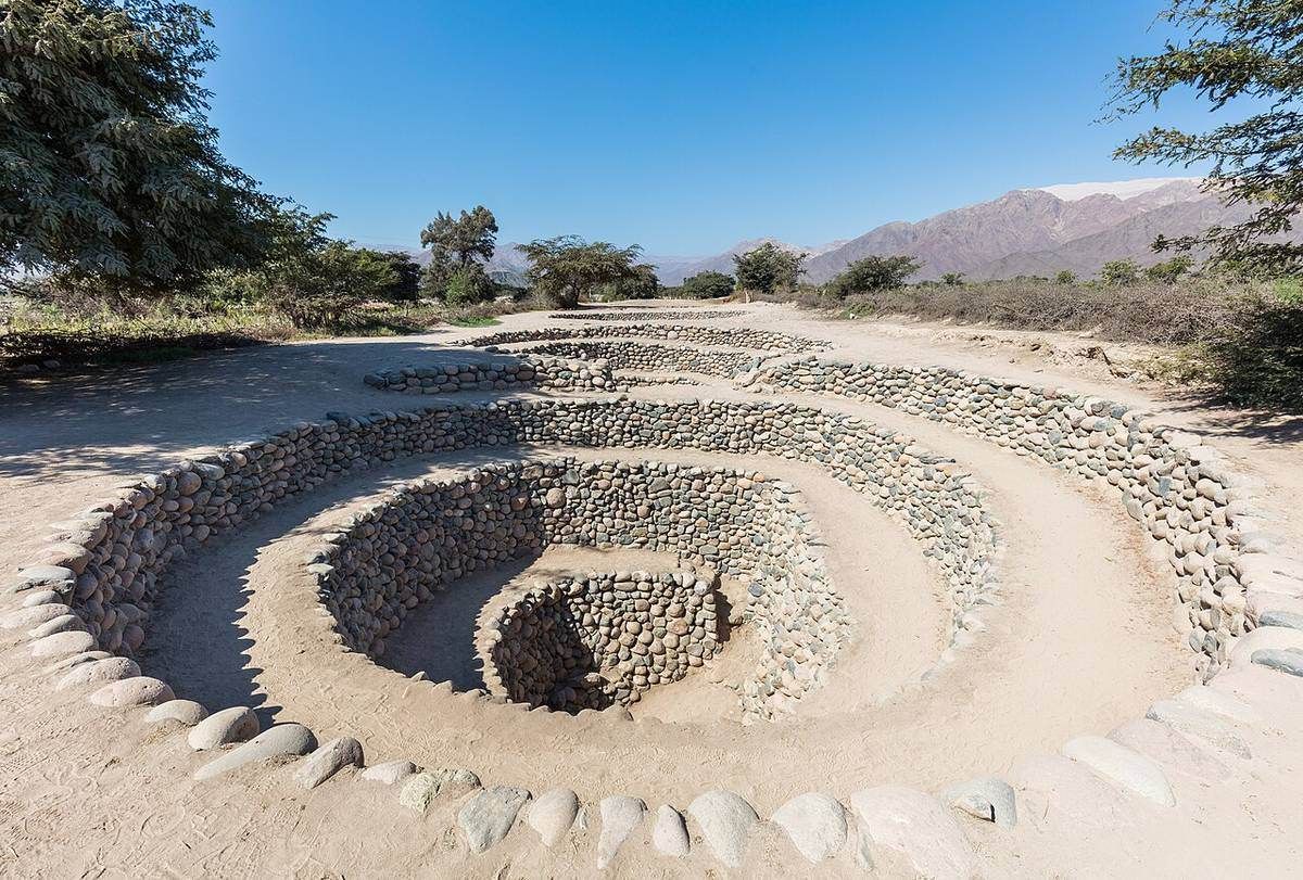
Archaeologist Katharina Schreiber climbed down into the puquios. She concluded that they and the most prominent straight lines were built around the same time, about the sixth century A.D., which was also a time of great drought.
In July 1996, a retired New York teacher named David Johnson stood on a hill called Las Agujas, looking down at a giant trapezoid. Two straight lines ran from it toward clefts in a distant peak. "My God, I know what the lines of Nasca mean!" he recalled saying. "They're tracing underground water sources!"
His methods were unusual. He relied on dowsing, which science does not accept. But a University of Massachusetts team tested the idea. Stephen Mabee, a scientist who studies underground water, put it simply: "We make maps of our water lines. Maybe the Nasca people did, too, and just put them on the ground." The team found at least five places where wells and water sources matched geoglyphs and old settlements.
Schreiber gave a mixed reply. "I think Johnson is right about some things, but not to the extent he claims," she said. Most of the 39 puquios she studied seemed to draw from under the riverbed. Yet the 2024 Yamagata paper still lists underground water as something some lines may be tied to.
Anthony Aveni, who wrote the book Between the Lines, took a different route to water. He and Gary Urton mapped some 800 straight lines and found that nearly all connect to 62 hubs he calls ray centers. Those hubs sit where water comes down to the valleys. "Everything points to water," Aveni said.
Explorer Johan Reinhard found a living parallel in Bolivia, where villagers walk a straight line of stones to a hilltop shrine while dancing and praying for rain. Lambers has noted offerings near the trapezoids, including corn, crabs and shells from as far off as Ecuador, all tied to water and fertility.
§ 7Walking the lines
Maybe the point was never to look at the lines at all.
British researchers Clive Ruggles and Nicholas Saunders spent 150 days walking 932 miles of the desert. They mapped a hidden path 2.7 miles long, with sharp, confusing turns. It ends, or begins, inside a spiral. You cannot take it all in by eye. "This labyrinth was meant to be walked, not seen," Ruggles said. It may have been for shamans or pilgrims, or even meant for the gods.
Saunders offered a striking thought. "It may be, we suggest, that the real importance of some of these desert drawings was in their creation rather than any subsequent physical use." Art historian Alan Sawyer noticed that most figures are one line that never crosses itself. A person walking it, he said, "could have felt they were absorbing the essence of whatever the drawing symbolized."
Others see people coming together. Isbell tied the work to the drafting of community labor. A 2026 study led by Charles Stanish suggests that early figures marked travel routes and camps, then became places for gathering and feasting. Darryl Wilkinson of Dartmouth believes walking the lines together built "a relatively more equal expression of community." The Yamagata team says some scholars have also tied the lines to running and dancing.
§ 8The figures nobody knew about
For nearly a century, researchers found 430 figures on the plain. Then Masato Sakai of Yamagata University teamed up with IBM. Their computer system studied sharp aerial photos and flagged more than 47,000 spots. Archaeologists sorted those down to 1,309 strong candidates. Then they walked out to look.
In six months, from 2022 into 2023, they confirmed 303 new figures. In their first season they reached only 341 of the candidates. In August 2025, Sakai announced 248 more finds, 160 of them figures. The total now stands at 893.
These new ones are different. The famous giants average about 300 feet and mostly show wild animals. The new ones average about 30 feet. They are built on slopes, close to old foot trails. They show people, llamas and cut-off human heads. Some show killer whales holding weapons. Sakai says Nazca pots show orcas cutting off human heads too.
The team now believes there were two kinds of drawing. The giants, near the network of straight lines, were probably community ritual spaces. The small ones were made and seen by a few people at a time, along the trails. "While walking, one can see a sequence of figures, as if they were conveying a message," Sakai said. "We believe that each path had its own meaning."
So the desert may hold stories, told in order to anyone walking by. No one can yet read them.
§ 9What it adds up to
The record says the Nazca people made these lines over many centuries. It does not say why, or how they saw their work. The stars, the water and the walks each explain some of the lines, and none explains them all. As art historian Ana Nieves told Live Science, "It is not likely that a single explanation would apply to all." The newest figures were found only because a machine looked where people had not. There may be many more out there, still waiting on the desert floor.
Watch & Listen
Hear this entry read aloud. Coming soon — the channels are not live yet.
Sources
Books
Chariots of the Gods, by Erich von Däniken. ISBN 9780425166802
Between the Lines: The Mystery of the Giant Ground Drawings of Ancient Nasca, Peru, by Anthony F. Aveni. ISBN 9780292704961
Nazca: Journey to the Sun, by Jim Woodman. ISBN 9780671808952 (not on Bookshop)
The new figures
- Sakai et al., "AI-accelerated Nazca survey nearly doubles the number of known figurative geoglyphs and sheds light on their purpose," PNAS 121(40), 2024: pmc.ncbi.nlm.nih.gov/articles/PMC11459208/ ; publisher page: doi.org/10.1073/pnas.2407652121 (site blocks automated checks)
- National Geographic, Anna Thorpe, "How hundreds of mysterious Nasca lines have been uncovered, with the help of AI" (11 May 2026)
- Andina, "Japanese researchers unveil 248 new Peruvian Nasca Lines geoglyphs" (4 Aug 2025)
The record, the stars and the purpose of the lines
- Live Science, Owen Jarus, "Why were the Nazca Lines built?" (24 Oct 2026), quoting Lambers, Richter, Nieves and Wilkinson
- UNESCO World Heritage Centre, Lines and Geoglyphs of Nasca and Palpa
- Association "Dr. Maria Reiche," Dresden: history of research nasca.geoinformation.htw-dresden.de/Englisch/historie.htm ; Reiche in Peru nasca.geoinformation.htw-dresden.de/Englisch/maria02.htm ; work on the pampa nasca.geoinformation.htw-dresden.de/Englisch/arbeit.htm ; the lines nasca.geoinformation.htw-dresden.de/Englisch/linien.htm
- Encyclopedia.com, "The Nazca Lines" (Kosok, Hawkins)
- Richter, Teichert and Pavelka, "Astronomical Investigation to Verify the Calendar Theory of the Nasca Lines," Applied Sciences 11(4), 2021: mdpi.com/2076-3417/11/4/1637 (site blocks automated checks)
- Stanish, Tantaleán, Tavera, Bongers and Wise, "A Theory of Andean Geoglyphs," Journal of Anthropological Research 82(1), 2026 (read through Live Science): doi.org/10.1086/739379 (site blocks automated checks)
Visitors and balloons
- Jason Colavito, review quoting Chariots of the Gods on the Nazca plain
- Encyclopedia.com, "Nazca 'Spaceport'" (von Däniken, Moseley, Woodman's claims and flight date)
- Boston Globe, "Erich von Däniken, who claimed aliens visited Earth, dies at 90" (11 Jan 2026)
- Julian Nott, the Nazca balloon
- Bonhams, Project Nazca archive (the 1975 flight and its sponsor)
- Katherine Reece, "Grounding the Nazca Balloon," Hall of Maat (quoting Woodman's book; the foothills)
Ground methods, water and walking
- Joe Nickell, "The Nazca Drawings Revisited: Creation of a Full-Sized Duplicate," Skeptical Inquirer, Spring 1983 (also quotes von Däniken, Kosok, Reiche, Isbell, Morrison and Sawyer, and gives the stake date)
- Space.com, Kieran Mulvaney, "Ancient Peruvian Mystery Solved From Space" (18 Apr 2016)
- Discover, Jack McClintock, "The Nasca Lines Solution" (Dec 2000; Johnson, Mabee, Schreiber, Aveni, Reinhard)
- ScienceDaily (University of Massachusetts Amherst), "Peru's Nasca Lines Point To Water Sources, Suggest UMass Researchers" (1 Dec 2000)
- University of Bristol, "New light on the Nazca Lines" (6 Dec 2012)
- Science News, Bruce Bower, on the Nazca labyrinth (2013)
- Live Science, "Nazca Lines: Mysterious Desert Drawings Form Labyrinth"


